All you need to know about Drone Surveying
SURVEYING
What is surveying?
Surveying refers to the detailed inspection of an object or area. It is commonly used to investigate infrastructure, developments or to assist with mining activities.
There are many different forms of surveying, infra-red, aerial photography and sensing tools just to name a few.
These methods can be very costly and time consuming and in today’s times we need to be fast and cost effective. Drones now allow us to save time and money.
DRONE SURVEYING
One of the more effective tools that allow you to obtain data a lot quicker and easier.
Today’s drone technology has many benefits.
- Lower operational costs
- Real-time reporting
- Reliable data collection
- A birds-eye-view of any terrain.
Here are a few ways drone surveying can save time and money, making any project more cost effective:
- STOCKPILE SURVEYS
- SLOPE MONITORING / DETECTION
- TOPOGRAPHICAL SURVEYS
Now the question that everyone is asking…. What are the pros and cons of Drone Surveying??
THE PRO’s:
- EASE OF DEPLOYMENT: Drones are able to complete survey projects in half the time of any traditional surveying method. Traditional surveying that took several weeks can now be done in a few short days, allowing projects to be done in less time.
- REDUCED RISK: Drones are able to go into harsh and hazardous terrains, allowing better collection of any data in any environment.
- DETAILED DATA: Drones are able to capture high-resolution images as they are equipped with imaging software which makes it easy to turn images into a wide variety of geo-referenced 2D maps and 3D models.
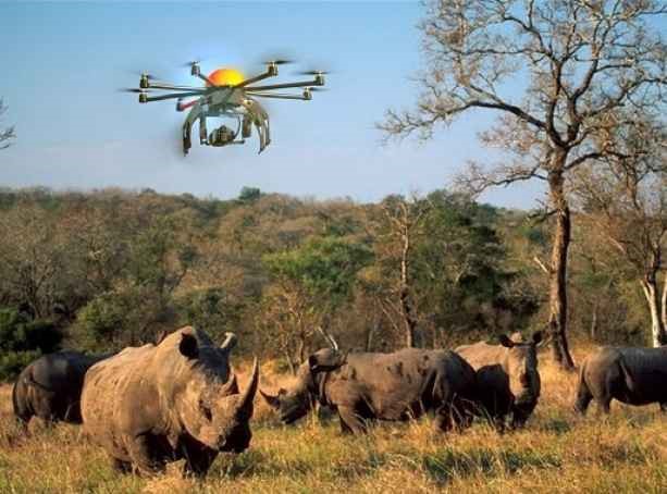
- WILDLIFE: Leads 2 Business are very passionate about saving Rhinos. Drone surveying greatly assists in the fight against rhino poaching and the protection of the environment.
THE CONS:
There are some concerns when it comes to drone surveying.
Government can restrict drones to only fly in certain areas. There can be legal and financial implications for any persons that are found to be in violation.
Thus, in short, the Pros out way the Cons by far, as long as you have all your legalities in order!
Click here to watch Heart of a Ranger.
Sources
Airborne Drones
DC Geomatics
Planet In House
Grind Drone
To view more articles, please visit the Leads 2 Business Blog.
If you are interested in becoming one of our subscribers, please visit Leads 2 Business.
To view notes with screenshots on how to use our website, please visit the Leads 2 Business Wiki.
About Connie van Tonder
I started working at L2B in April 2017 as an Accounts Executive. Not knowing too much about the construction industry. Learning new things every day and enjoying every second of it. Loving what I do!

vanphongchothuesaigon.net
Thanks , I’ve recently been searching for information about this topic
for a while and yours is the greatest I’ve found out so far.
But, what concerning the conclusion? Are you sure in regards
to the supply?
Sasha Anderson
Good Day,
Thanks for getting in touch with us. We will look into the feedback you have provided. f you would like further information please email us on support@l2b.co.za